FREE RESOURCES
Developed by GEOetc Earth Science educators so you can use them right in your class.
(Want more resources? Then look at the Member Resources page)

Have you wanted your students to learn about observing and writing accurate descriptions? Then this activity is for you! It ...

Print your own rock posters - downloadable PDF file. 4 full-color pages for Sandstone, Shale, and Conglomerate. Each poster is ...

A series of 3D cut out paper models that show the work of rivers including: River delta model (deposition) Grand ...

A 3D cutout paper model that shows a tsunami. All students need is a printer, scissors, and glue to make ...

A 3D cutout paper model that shows a range of cave formations such as : Sinkhole Sinking creek Stalactite Stalagmite ...
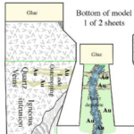
A series of 3D cut out paper models that show aspects of mineral resources including: Mine model showing mining terms ...

A series of 3D cut out paper models that show the different forms of glacial features including: Antarctica Ice Sheet ...

A series of 3D cut out paper models that show the different forms of sand dunes including: Parabolic Dunes Barchan ...

A series of 3D cut out paper models that show the major trap types for oil and gas. The trap ...

A series of fossil and dinosaur paper models for your students to build including: Trilobite Nautiloid T-Rex Triceratops Pterosaur All ...
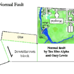
This includes the major fault types and structures: Normal fault Thrust (reverse) fault Strike-slip (left) fault Strike-slip (right) fault Oblique ...

This includes the major volcano types - both in color and in black-line. Shield Volcano Stratiform/Composite Volcano Caldera Cinder Cone ...

An in-class simulation where students play the role of scientists providing information about the possible eruption of volcanoes on an ...

Have your students calculate the speed of the moving Pacific Plate using the ages of rocks collected on the different ...

A data calendar blank to record data collected each day in the Northern Hemisphere. Data can be recorded in ...

A data calendar blank to record data collected each day in the Northern Hemisphere. Data can be recorded in ...

Have your students examine how changes in iPhone design over time may lead an iPhone to become an index fossil in the future. iPhones have changed in size, shape, type of buttons, type of charging cables, having front 'home' buttons, removal of headphone sockets, adding cameras, and more over time. We know when each model was released, so we can use the release of a new model with destructive features to act as a potential 'index fossil'. This activity can ...

Have your students listen to this podcast on radioactive dating. It goes just under 8 minutes. Then have them do this simple activity reading a radioactive decay curve. Students work out the ages of zones in a zircon mineral by reading a radioactive decay curve. They then need to calculate the average age of the crystal. Downloadable activity (Download) This activity also is in the Members Resources section. Members get full access to all the activities, which include the teachers ...

Here is a great activity for your students if you are starting them off on a Plate Tectonics topic - or as part of your discussions about the layers of our planet. Have them listen to this podcast (it is less than 9 mins long) and then complete the activity worksheet below. Have your students label a diagram of the Earth's interior layers - on one side are the chemical layers (Crust, Mantle, Core), and on the other side the ...

Have your students practice reading directions from a compass - cardinal points as well as bearings. This is an important skill for any students wanting to do a field-based science study. This activity would take students 15-25 mins to complete. Downloadable activity (Download) GEOetc Members have access to more activities like this, along with suggest answers. Check out all the resources you could access to as a GEOetc Member ...

A teaching resource by Mariana Garcia Serrato San Jose, CA, USA For several years I have been teaching Plate Tectonics to students and we have done several paper-pencil activities that have to do with plotting earthquakes, volcanos and landforms on maps. Over those years, I've searched far and wide for a Google map that included the outlines of the plates in the hopes of turning those activities into a digital product. I've only ever found Google Earth maps with this ...
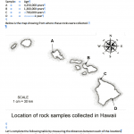
Have you students calculate the speed of the moving Pacific Plate using the ages of rocks collected on the different islands. Students measure the distance between the collection site and then work out the age difference between the sample. They can then calculate the speed the plate must be moving over the Hawaiian Hotspot – giving an approximate speed and direction for the Pacific Plate. Downloadable activity (Download) Downloadable suggest answers (Download) ...
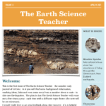
Welcome to The Earth Science Teacher. This is the quarterly member's journal of GEOetc.com. Each quarter a new topic is covered that is relevant to the teaching of Earth Science. It is not full of 'research papers' - it is practical information and ideas for people teaching Earth science anywhere on the planet. It normally contains background information, activity ideas, links to stimulus materials (like videos) and a Member Speaks section where a GEOetc member talks about their experience related ...

Have your students read data from a USGS lava risk map and interpret the most dangerous locations and where they would want to locate. This activity would take students 15-20 mins to complete. This is a great activity for Natural Hazards and allows students to use a REAL USGS map for the Big Island of Hawaii. Suggested answers and a downloadable full-size map image are provided for members here. GEOetc has a Members Resources section that for a small cost ...

An in-class simulation where students play the role of scientists providing information about the possible eruption of volcanoes on an island. Have your students list to this 9-minute podcast on how volcanoes are monitored (this is optional) You split your glass into these groups: Deformation team Well water and Weather team Seismic team Eruption Center You are provided with slips of paper with data for each team for each time period. Each team has instructions on what to do with ...

This is an activity where students listen to a 9-minute podcast on the basics of river morphology and then examine 5 world rivers using Google Maps or Google Earth. Students are asked to write down their observations of each of the rivers, draw a small sketch of the main features and then ask meaningful questions that they would ask to learn more about each of the rivers. This is a great way to start off a unit on rivers - ...
Join our email newsletter for more activities, information and opportunities. Join here!
OTHER RESOURCES
These resources require a small payment as they are full curriculum and contain videos, classroom activities, teacher guides and more. Click on titles for more information.
This resource shows how the STEM fields can be used on an active volcano on the island of Hawaii. The resource contains videos on each field (5-10 mins each), teaching notes and reproducible classroom activities to extend the learning with students.
STEM on an Active Volcano has been developed to provide teachers with materials that are aligned with the US New Generation Science Standards and Common Core mathematics practices.
COST: US$24.95 (digital download of all materials)
This simple guide will help you to understand the fundamental principles of the theory of plate tectonics. It covers the history of the theory, the structure of the Earth, the types of crust, the types of plate boundaries, evidence for plate tectonics and more. This is perfect for teachers, educators and students.
FIELD ADVENTURES
 Join us on one of our teacher professional development trips to Hawaii, Iceland, Australia, Italy and more.
 STEM on an Active Volcano
 Plate Tectonics – a simple guide