The Earth’s plates don’t just sit there. They move and interact at their boundaries – and that is what makes our planet so dynamic. The volcanoes, the earthquakes, and even climate are all related to the movement and position of the Earth’s plates.
There are three ways that plates can interact at their boundaries. They can move apart from each other. They can move towards each other or then can slide past each other. Each of these plate boundaries have different geological and related topographical features.
Moving Apart Boundaries
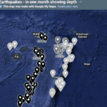
In many locations, the great plates are moving apart, or diverging, from each other. For this reason, we call these Divergent Plate Boundaries. In the space created as the plates move apart, molten rock wells up and creates new plate material to each plate. This new material is always basalt (and its intrusive equivalent) and so this is where new oceanic crust is being formed. The rocks along these boundaries are hot due to the upwelling of molten rock and this means the rocks are expanded (hot things expand…right?) causing a long ridge to form. This is the famous Mid-Ocean Ridges that mark divergent boundaries. The plate here is thin – around 5-10 km – and so any earthquakes that occur are shallow.

The Mid-Atlantic Ridge is a divergent plate boundary where the North American Plate is moving away from the Eurasian and African Plates. (Black dots and circles are earthquakes)
Moving Together Boundaries
When plates move together, we say that are converging, and so these are Convergent Plate Boundaries. How the plates interact very much depends on the type of crust at the boundary.
Oceanic plate to continental plate
Oceanic crust is more dense than continental crust. So when they converge, the plates topped by oceanic crust tends to be pushed under the plates topped by continental crust. We say that it is being subducted under the continental plate, and so these are Subduction Plate Boundaries. As the oceanic plate has to bend to go under the other plate, it forms a deep valley or trench, and these are the famous deep ocean trenches around the globe. As the plate is subducted it scrapes along the overlying continental crust causing earthquakes that start shallow right at the boundary, then get deeper and deeper as you move under the plate. Some of this ‘rubbing’ causes melting in the overlying continental crust (the process is a little more complex, but its a good way of thinking about it) which can rise to the surface and form a chain of stratiform volcanoes.
The slab of oceanic plate gets pushed into the underlying mantle and eventually remelts.

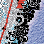
The Aleutian Trench is a subduction plate boundary where the Pacific Plate if being forced under the North American Plate. (Black dots and circles are earthquakes, red triangles are volcanoes)
Continental plate to continental plate
When a boundary between two pieces of continental plate collide neither of the plates wants to be pushed under the other. The result is that the colliding plates form huge mountain ranges as the continental crust is forced into each other. These are known as Collision Plate Boundaries. Earthquakes at these plate boundaries are not zoned and can be shallow to deep. Volcanoes do not normally occur.

The Himalayan Mountains is a collision plate boundary where the Indo-Australian plate has collided into the Eurasian Plate. (Black dots and circles are earthquakes, red triangles are volcanoes)
Sliding Past Each Other Boundaries
In some locations, two plates are sliding past each other. Here a huge fault zone exists along which the plates slide causing earthquakes. It is not normally a place for volcanoes. The topography includes cut off valleys and altered drainage patterns as the plates slide past each other. We call these Transform Fault Boundaries.

The San Andreas’s fault complex is an example of a transform fault boundary where the North American Plate is sliding past the Pacific Plate. (Black dots and circles are earthquakes, red triangles are volcanoes)

The Alpine Fault in New Zealand is another example, where the Ind0-Australian plate is sliding past the Pacific Plate. (Black dots and circles are earthquakes, red triangles are volcanoes)
But it is not always so simple…..
While it is easy to understand these boundary types, most of the plate boundaries exist as hybrids of two of these types. You can have, for example, slight subduction with a transform fault boundary and the boundary can change back and forward along its length.
The diagrams in this blog are from an awesome USGS product called This Dynamic Planet. For details go here.
For more of our blogs on Plate Tectonics see these posts:

Writing Prompts

Microfossils
Shale – and how we use it.
Sandstone – quartz, arkose and lithic
Apparent Polar Wandering & Plate Tectonics
Seismic Shadow
Seeing Inside the Earth

Tectonic Plates – Lithosphere, Moho, Asthenosphere
Plate Tectonics Battleships
Earth’s Plate Tectonic Features – ld
World Earthquakes by Depth – LD

Divergent Dilemma
What is the history of the theory of Plate Tectonics?

What are the mechanisms that drive Plate Tectonics?

Seeing inside the Earth

Earth’s Interior Layers

Earth’s layers explained

Plate Tectonics Google Map
Benioff Zones – earthquake evidence for subduction
Structure of Earth

Volcano shapes – shield, composite/stratiform, caldera – and chemistry
Transform fault plate boundaries – what are their features?
Convergent plate boundaries – subduction, collision and Island arcs – what are their features?
Divergent plate boundaries – what are their features?
The Evidence for Plate Tectonics
Earth’s Magnetic Reversals, Polar Wandering and Plate Tectonics

Earthquakes – what you need to know!
Introduction to Plate Tectonics
Lava in Lihue – Role play activity
Rocks of Ages

Evidence for Plate Tectonics

Boundaries – how the plates interact

Plates – understanding the tectonic jigsaw pieces.

Really enjoying your content, thank you.
These are fabulous!!! I’m so excited to share them with my students!